Whoops. Chris will tell you I've been paranoid since we started that one day we would end up at totally different locations. He teased me a little as I would double check and then triple check the town and address for meeting up. Well, today my paranoia was legitimized. Totally my fault, but made for an interesting afternoon. We decided on the Iron Horse Campground in Damascus as our destination tonight. Chris headed out, and we followed a little while later. We stopped for groceries and lunch, and then I went to put the address into the GPS. I used my phone to do a quick Google search for the campground and the first 5 links that came up were Iron Mountain Horse Campground. I noticed the city for the address was not Damascus, but I figured it was close and zoomed out on the map to check the direction. It looked...probably right? Gave Chris a quick call to double check, but no answer (not surprising as we've been going through several areas in the mountains with no cell reception).
You can guess where this story is going. Forty minutes of winding country roads later we pull into a horse stable and campground. Seemed like a nice place, I thought, and started looking for Chris. This time I was the one getting no cell reception. While we were hanging out on the deck of the unmanned tack shop, I started looking for a map, still not sure if we were in the right place. There was a very hard to read one posted on the wall. After much squinting, I realized...we were a long way from Damascus. A nice lady stopped by to ask if we needed anything and helpfully pointed out that "Damascus was over an hour and a half away". Like I said, whoops.
So, off we went back through Wytheville in search of the Iron Horse Campground! The upsides were that it was a beautiful drive all around, probably the best scenery so far, and I drove about 10 miles on Route 76 (Chris' bike route), so it was neat to imagine what it had been like to ride through. I'll admit I have been missing riding myself, just a little here and there in the evenings. We made it to the right campground without event this time.
Shown below, August "Wake Me Up When We Get There" Hill.
Chris suggested we ride the Virginia Creeper Trail (real name) a few miles into the town of Damascus and get dinner. It was a gorgeous night for a ride, not too hot and the Creeper Trail is a great one. Once in town we couldn't resist the views at the Old Mill Restaurant, a surprisingly large inn/conference center/restaurant that overlooks the wide Laurel Creek. The food was tasty, not too expensive, and our server was really friendly as well. Chris ordered The Virginian, which was fried chicken with sausage gravy and a side of mashed potatoes with seasonal vegetables. I got the rainbow trout with cornbread stuffing and vegetables, and we shared a smoked trout dip appetizer. I would definitely recommend it to other travelers.
"May I see the milk list please?"
Six different trails go through Damascus, including the Appalachian Trail, which makes it a town very familiar with and happy to receive the business of hikers and cyclists. Our server said 50 Appalachian Trail hikers had been through the inn alone over the weekend. There is a church hostel that I'm sure sees even more hikers than the inn since it is free, so I wonder what the total numbers for it are. I am hoping to do a little exploring tomorrow before taking off.
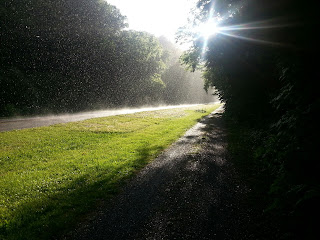
It was starting to look like rain, so we headed straight back to the campground after dinner instead of taking an extended ride as we planned. On our ride home, it was a full rain by about a mile from our campsite, and we were treated to this unique scene. A perfect ending to the day.


No comments:
Post a Comment